TRANSMISSION // 2611.07433v1
Teaching AI to locate Earth’s magnetic boundary in simulated X-ray images
Source published
MP-DualNet combines image classification with pixel-level mapping to locate the magnetopause in simulated observations for SMILE’s Soft X-ray Imager. The preprint reports 94.8% classification accuracy and an average boundary displacement of about half a degree, but real-observation performance remains untested and a simulated storm exposes limits in detailed boundary tracing.
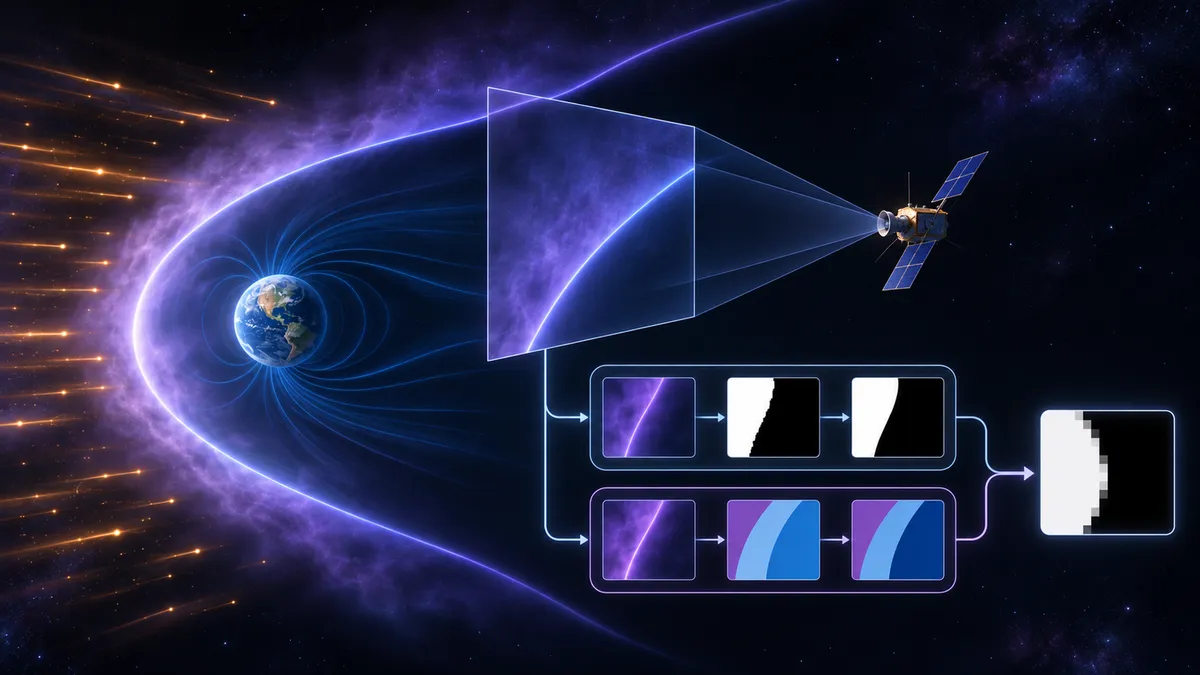
Earth’s magnetopause shifts as the solar wind pushes against the planet’s magnetic environment. A new deep-learning study explores how to track this moving boundary in soft X-ray images—even when the camera’s view does not contain the whole feature.
A moving boundary, seen indirectly
The magnetopause separates Earth’s magnetosphere from the magnetosheath, the region of shocked solar wind outside it. Its position and shape respond to solar-wind pressure and the interplanetary magnetic field. Tracking those changes helps researchers understand how Earth’s magnetic environment responds to space weather.
Spacecraft can measure the boundary locally, but scattered measurements cannot continuously reveal its global shape. Soft X-ray imaging offers a complementary view. Highly charged solar-wind ions capture electrons from neutral atoms near Earth, producing X-ray emission through a process called solar wind charge exchange. Emission from the magnetosheath carries information about the boundary’s geometry.
The challenge is that an X-ray image is not a straightforward outline. Each pixel combines emission along a viewing direction, so the brightest features need not coincide with the magnetopause. The boundary can also move partly or entirely outside the camera’s field of view.
In a preprint posted on November 5, 2026, Cheng Zhong and colleagues introduce MP-DualNet to address these problems using simulated images for the SMILE mission’s Soft X-ray Imager, or SXI.
Two branches with different jobs
MP-DualNet analyzes each image through two independent U-Net-based neural-network branches. U-Net combines broad spatial context with finer image details.
The first branch classifies the projected boundary as predominantly beyond the left edge, inside the field of view, or predominantly beyond the right edge. The second assigns each pixel a probability of lying on the magnetospheric side of the projected boundary.
The system combines those outputs, weighting the detailed map by the probability that the boundary is inside the image. A threshold then produces a binary mask. When an outside-view category dominates, the output mainly conveys the boundary’s relative direction—not a detailed reconstruction of an unseen boundary.
This distinction matters: MP-DualNet estimates a two-dimensional projected envelope. It does not directly reconstruct the three-dimensional magnetopause or determine its distance from Earth along the Sun–Earth line.
Learning from synthetic observations
All development data were simulated. Three global hybrid simulation runs supplied different fixed solar-wind and magnetic-field conditions, including solar-wind densities of 7, 20 and 60 particles per cubic centimetre. The researchers generated X-ray intensity images by integrating simulated emission along viewing directions selected from the nominal SMILE orbit.
Reference boundaries came from a plasma-mixing criterion within the simulations, projected into the image plane. These references describe large-scale envelopes rather than the internal structure of the physical boundary layer.
The native images contained just 375 pixels, with one-degree angular spacing. They were resized for the network, while image-by-image logarithmic scaling, percentile clipping and normalization adjusted contrast. Noisy versions of each source image remained in the same training, validation or test subset, reducing leakage between development and evaluation.
The three visibility categories were equally represented. That balance supports comparison between categories, but does not represent their expected frequency during mission operations.
Strong reported scores, with important boundaries
The authors report test classification accuracy of 94.8%. The fused masks achieved an intersection over union of 0.972 on the full balanced test set: a measure of how closely predicted and reference regions overlap.
A more directly geometric measure gave a mean absolute boundary displacement of 0.488 degrees. That calculation concerned reference images classified as Inside by their labels and used rows where both predicted and reference boundaries existed. It should not be interpreted as an error guarantee for every image or a measurement of three-dimensional distance.
In one independent synthetic image, MP-DualNet’s mean angular difference from a common reference was 0.33 degrees, versus 0.46 degrees for a tangent-fitting curve reconstructed from published parameters. The authors explicitly limit this comparison to that example; it does not establish general superiority over tangent fitting.
What the harder tests reveal
A controlled noise experiment found overlap scores of roughly 0.96–1.00 across increasing background amplitudes for a representative image. However, the added noise was uniformly distributed random intensity, not photon-counting noise. The simulations omitted instrument response, exposure-dependent photon statistics and a physical cosmic X-ray background model. Robustness here is therefore narrower than robustness to actual SXI observations.
An independent simulated sequence based on the May 2024 geomagnetic storm provided a tougher test. The model captured the large-scale boundary motion, but detailed overlap deteriorated at several times, reaching about 0.51 in an Inside frame. High visibility confidence did not ensure accurate local tracing.
The authors propose broader training conditions, temporal information, uncertainty-aware boundary labels and adaptation to real observations. These remain future developments. The present result is a promising simulated-image boundary detector that could support later physics-based reconstruction—not yet a validated operational space-weather tool.
- magnetopause
- MP-DualNet
- SMILE
- Soft X-ray Imager
- solar wind charge exchange
- deep learning
- space weather
- simulated observations
Related reading
Automatically matched by shared topic keywords. These links do not imply that the sources agree or establish a consensus.