TRANSMISSION // 2611.05859v1
Generative AI for urban planning: synthesizing land-use maps with satellite imagery via DualControlNet
Source published
A preprint introduces DualControlNet, which generates land-use maps alongside satellite-like imagery from planning prompts and spatial controls. Tests in Chicago and Orlando show improved alignment on several measures, but mismatched land uses, unstable orientations and disconnected tiles remain important limitations.
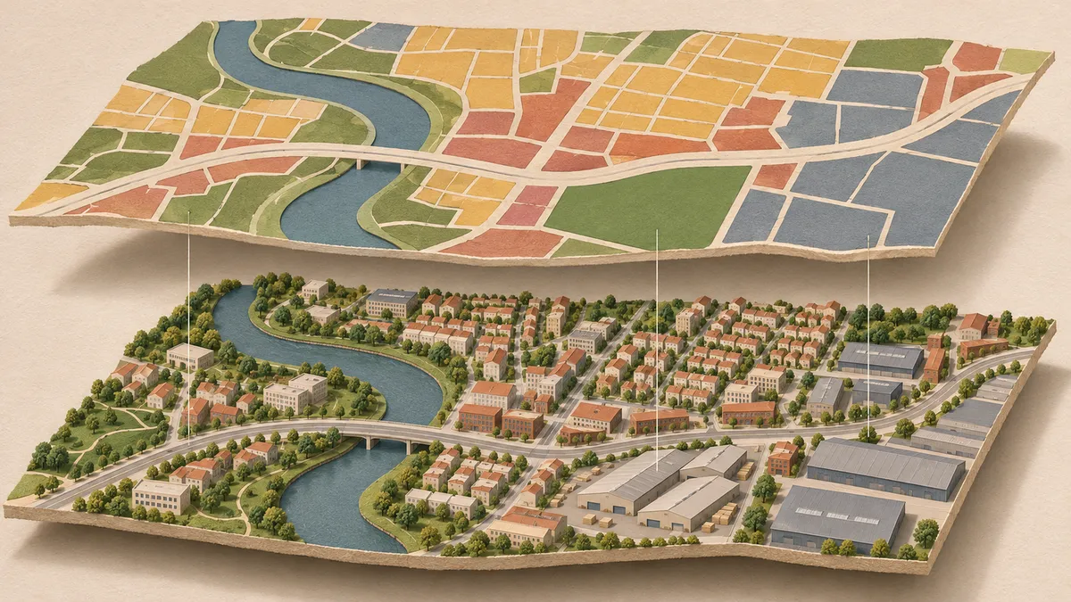
What might a neighborhood look like if more of its land were covered by buildings, or if it contained a wider mix of uses? Qingqi Song, Yuzhou Chen, Lingqian Hu and Shenhao Wang explore that question in a preprint posted on November 4, 2026. Their model creates paired visual scenarios rather than predicting which future will actually occur.
Two views of an imagined neighborhood
DualControlNet produces two complementary outputs: a color-coded land-use map and a synthetic satellite-style image. The map describes functions such as residential, commercial and green space; the image depicts building patterns and landscape textures. The authors argue that generating both together can make planning alternatives easier to inspect while retaining measurable categories for checking them.
The distinction between a scenario and a forecast matters. These are generated possibilities, not satellite observations of proposed developments or predictions that those developments will happen. The researchers present their approach as a complement to predictive land-use modeling, focused on envisioning and comparing alternatives.
How the controls work
The study uses more than 40,000 paired training tiles from Chicago and Orlando, with another 4,000 pairs reserved for testing. Each tile covers approximately 450 meters by 450 meters. Satellite imagery comes from Mapbox, while land-use labels and spatial controls come from OpenStreetMap. Control maps show major roads and water bodies.
For each tile, the researchers calculate nine measures, including building coverage, land-use diversity and road density. They translate these into structured prompts containing both descriptive language and numerical values. Building coverage means the fraction of land occupied by building footprints, not building height or population density.
The model builds on ControlNet, an approach for guiding image generation with spatial inputs. Its additional geometric training penalty encourages boundaries in the two generated views to align. After generation, the team recovers land-use measures from image colors and compares them with reference values. Separate checks examine boundary alignment and visual realism.
Improvements come with tradeoffs
The paper compares two joint-generation variants, with and without the geometric penalty, against separate land-use-only and satellite-only ControlNet models. Building-coverage consistency reaches 0.7400 with the penalty, compared with 0.6362 for the land-use-only baseline: a reported relative gain of 16.3%.
The headline 62.8% improvement in land-use diversity consistency needs a qualification. That best result comes from the joint model without the geometric penalty. Adding the penalty improves building-coverage and average land-use-area consistency but reduces diversity consistency. The modification therefore does not improve every measure simultaneously.
The full model also more than doubles a gradient-based alignment score relative to the unimodal baselines. For visual realism, its overall Fréchet Inception Distance is 58, compared with 61 for the satellite-only model; lower is better. This image-distribution measure does not establish geographic validity, as the paper explicitly notes.
Responding to development goals
In one scenario experiment, requested building-coverage ratios of 0.35 and 0.60 produce measured values of 0.36 and 0.61. The authors also show that an identical density prompt can yield different residential, commercial or industrial-looking configurations. Matching one number does not determine a unique neighborhood.
Control is less exact when objectives are combined. At an Orlando site, a prompt requesting 0.45 building coverage and five land-use categories produces 0.46 coverage and six categories. These examples support responsiveness to the selected controls, rather than guaranteed compliance with every requested target.
Why inspection remains essential
The same Orlando example exposes a substantive contradiction: the land-use map marks an area green while its paired satellite-style image shows warehouse facilities. The paper also reports confusion near wetlands and water, occasional map flips and orientation errors, and discontinuities between neighboring generated tiles. Those failures limit how readily individual outputs can become a coherent larger map.
Input quality is another constraint. The authors acknowledge that OpenStreetMap labels are insufficiently detailed in undeveloped areas and can be inconsistent across regions. They propose finer sources, including official plans and parcel maps, and identify additional cities as future work.
The authors frame increased density and diversity as sustainable-development scenarios. Their reported checks concern land-use measures, spatial agreement and image quality, rather than demonstrated sustainability outcomes. The preprint's useful proposition is a control-and-check cycle for exploring alternatives; its own failures show why a convincing picture cannot replace verification.
- urban planning
- generative AI
- DualControlNet
- land-use maps
- satellite imagery
- scenario planning
- spatial consistency
Related reading
Automatically matched by shared topic keywords. These links do not imply that the sources agree or establish a consensus.
A two-stage reasoning system helps AI choose Earth-observation evidence
Source published
Shared keywords: satellite imagery
AI transparency serves builders better than end-users, survey suggests
Source published
Shared keywords: generative ai
AI Express proposes one credit balance for multiple AI tools
Source published
Shared keywords: generative ai
When cheaper AI-assisted research makes scientific verification harder
Source published
Shared keywords: generative ai
When AI Makes Research Cheaper, Verification Can Become the Bottleneck
Source published
Shared keywords: generative ai